
Understanding Soils: Resources for Small Forest Landowners
As a small forest landowner, understanding the relationship between soil types and vegetation is crucial for successful land management. The adage “right tree in the right location” highlights how the soil type directly influences what trees can thrive on your property. Soil is the foundation of any forest ecosystem, providing essential nutrients, water retention, and habitat for microorganisms that support plant health. In forested areas, the soil type directly influences tree growth and overall biodiversity, water quality, and ecosystem resilience.
For instance, certain soils can support a diverse array of species, while others may favor just a few. Moreover, soil’s physical structure affects its ability to absorb water and nutrients, which in turn impacts forest health. We’ll provide some resources to assess your soils as you consider how to best manage your forest.
Soil Types
The first step in managing your forest effectively is identifying your soil type. Different soils support different vegetation types, and how you manage your soils also influences how vegetation grows. For instance, sandy soils drain quickly and can be less fertile, while clay soils retain moisture but may lead to poor root growth if compacted by heavy equipment. Here are some common soil types, their suitability for various tree species, and how they may affect management activities:
- Sandy Soils: Well drained, ideal for drought-resistant species like pines. It may be operated on year-round unless there is a high water table.
- Clay Soils: Poorly drained; best suited for moisture-loving species like cedar, hemlock, or spruce. Prone to compaction and rutting if operated on during wet weather.
- Loam Soils: A mix that typically offers good drainage and fertility, supporting a variety of trees. Prone to compaction and rutting if operated on during wet weather.
- Glacial Till: Well drained and often droughty. Usually only suitable for the most drought-resistant tree species, such as oak, Douglas-fir, or pines. Often suitable for winter logging due to better drainage and stability.
Seasonality and Soils
Soil composition also affects when you can log your forest. For example, clay and loam soils are generally unsuitable for winter logging due to their tendency to become muddy and compacted. In contrast, glacial till soils can withstand winter conditions better, allowing for logging activities without damaging the land. Knowing your soil type can help you plan logging seasons more effectively, minimizing potential damage and maximizing productivity.
Understanding your soil is vital to effective forest management. It can lead to better decision-making regarding tree selection, logging practices, and overall forest health. By learning about your soil types, you can enhance your forest’s productivity and sustainability.
Soil Productivity
Two common soil productivity indices define the growth potential for forest biomass and timber on any given soil: Site Index and Site Class
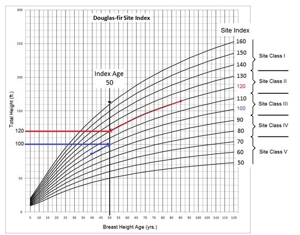
Tree Site Index
The tree site index measures how tall a particular tree species can be expected to grow within a given time, usually 50 years. It helps forest managers and landowners evaluate how well certain tree species will grow on their land. The site index for a particular soil can be found using the NRCS Web Soil Survey.
When applied to forest soils, the site index provides the following insights:
- Tree Growth Potential: It indicates how productive the soil is for growing trees. A higher site index means better growth conditions (e.g., deeper, well-drained soils). In contrast, a lower index suggests poorer conditions (e.g., shallow or nutrient-deficient soils).
- Species Suitability: Different tree species have different site index values based on their response to specific soil conditions. The index helps determine which species would perform best on your land.
- Forest Management Decisions: Knowing the site index can guide management practices, such as tree planting, thinning, and harvesting schedules, by helping you predict growth rates and timber yield.
- Soil and Site Quality: It reflects underlying soil characteristics like fertility, moisture availability, depth, and the influence of climate on plant growth.
Tree Site Class
Tree site class is a more generalized indicator of soil productivity and simply groups site indexes into five categories, with site class, I being the most productive and V being the least.
Resources for Identifying Soil Types
There are a number of resources available to help you determine your soil types. Below are a couple we recommend.
The NRCS Web Soil Survey (WSS) is an online tool provided by the Natural Resources Conservation Service (NRCS), a branch of the U.S. Department of Agriculture (USDA). It allows users to access a vast database of soil information across the United States. The WSS provides detailed reports on:
- Soil types and properties: Identifying soil composition, texture, depth, drainage, and chemical properties.
- Land use suitability: Offering guidance on how different soil types suit agriculture, forestry, urban development, and conservation.
- Soil management recommendations: Suggesting best practices for managing soil for specific crops, construction projects, and environmental restoration efforts.
The tool is used by farmers, landowners, engineers, and environmental planners to make informed decisions about land use and management. It is free to access and provides comprehensive, localized soil data. The tool can feel a bit overwhelming at first, but it can be a lot of fun to explore with some patience.
Some tips for using the tool include –
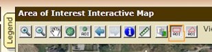
- Use the Area of Interest tab to zero in on the location of your land. You can either zoom in on the map or enter your land’s street address or latitude and longitude under “quick navigation.”
- Select the appropriate tool before clicking on the map to Zoom in and out or move around the screen.
- Once you’ve found your land, you must draw a polygon around its boundaries to access the soil data specific to it. Use either the AOI rectangle or the AOI polygon tool to draw your boundaries.
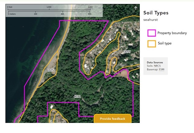
- After drawing your property boundary, choose the “Soil Map” Tab to generate a map of the soil types on your land.
- A trove of information on your soils can be found by selecting the “Soil Data Explorer” tab and following these steps:
- Select the “Suitabilities and Limitations for Use” tab
- The resulting “Land Management” and “Vegetation Productivity” tabs provide the most relevant information for forest management.
- Click “view description” to learn what the category of information means and then “view rating” to see the soil data results.
- Use the Shopping Cart (free) feature to get printable reports that you can download immediately or later.
We recommend this resource from Washington State University Extension for a more detailed explanation of the WSS.
LandMapper is a mapping tool developed with our friends at Ecotrust to help landowners quickly and easily generate a series of resource maps for their land. Landmapper is only available for landowners in Oregon and Washington and has less of a learning curve than the NRCS Web Soil Survey, but does not provide the same level of detail.
Here’s how to use the tool:
- Enter an address or zoom in on the map to choose your forest
- Click on the map to select a tax parcel (use the control key to select multiple)
- Create maps
- Scroll down to see the different data provided for the parcel you chose.
- Relevant maps include:
- Soil types
- Forest community types
- Forest canopy cover
You can make informed decisions about tree species, logging practices, and overall land use by identifying your soil type and using tools like the NRCS Web Soil Survey or LandMapper. The health and productivity of your forest depend on your ability to work in harmony with the soil’s unique characteristics. These tools are a great start, and we will share more resources at the bottom of this newsletter. If you need help interpreting what you learn, we have an Ask a Forester section in our newsletters, and NNRG offers free workshops throughout the year where you can talk with experts.
For more help with the Web Soil Survey tool, join our Fireside Chat on October 16th at 7:30 p.m. to hear from NRCS Washington’s Soil Scientist Max Ross.
Leave a Reply